 Studytipsgh Studytipsgh is to provide effective study strategies and tips to help students get more knowledge to better their Education.
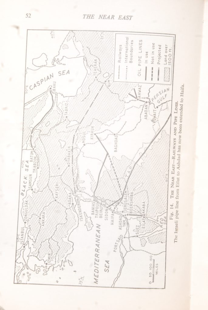
Geography Asia – THE NEAR EAST
THE NEAR EAST – The area extending from the Black Sea to the Gulf of Aden is often called the “Land of the Five Seas”-a very apt name; the five seas bordering it being the Black Sea, the Mediterran- ean, the Caspian, the Persian Gulf, and the Red Sea. It is easy to see why it has been such a bridge-land between Asia on the one hand and Europe and Africa on the other, and why it has been such a meeting-place of races and has had such a rich and varied history. Incidentally, the term Middle East is often wrongly applied to this area.
Politically the region includes Anatolia, Iran, Syria, Iraq, Israel, Jordan, Yemen, the Federation of Southern Arabia, the Hadramaut, and Oman, etc. As this covers far too wide an area for a detailed study we deal in this chapter only with general considerations and the details of Arabian lands. Structurally there are four sub-divisions. In the north there are the great plateaux of Anatolia and Iran, flanked by their fold ranges. Secondly, there is the trough of Mesopot- amia, a synclinal lowland. Most of it is composed of fertile alluvium deposited by the Tigris and Euphrates and removed by them from the former region.
Thirdly, the shorelands of the Levant consist of the narrow coastal plains of the Lebanon and Israel, backed by the Lebanon Mountains and the plateau of Judea. The Rift Valley forms a great trough from north to south across the area. Lastly there is the Arabian Plateau with its steep, tilted edge facing the Red Sea and a gentle slope towards the Persian Gulf.
Climatically, the whole area has several common character- istics. The summers are hot and dry and there is a deficiency of rainfall except in Mediterranean and Black Sea coastal areas. The rain falls in winter when the temperatures vary considerably according to altitude and position (latitude and distance from the sea), from the bleakness of the Persian Plateau to the heat of Aden (mean January temperatures: Teheran, 35° F.: Aden, 76° F.).
Iraq
This Arab Republic, based on the valleys of the Tigris and Euphrates, became completely independent in 1932, having been under British Mandate since the end of the First World War in 1918. From 1918 it was a Kingdom, but in 1958 a revolution resulted in the formation of a Republic. Like the rest of the Arab lands, it had previously been for some cen- turies under Turkish rule. During that time nothing had been done to repair the damage done by the Mongols, so that all the ancient irrigation canals had fallen into disuse and the country could support only a fraction of the population which flourished there in the days of Babylon. In an area of 170,000 square miles there are 63 million people, i.e. about 32 to the square mile, and the standard of living is low. Remember that Iraq forms part of the “Fertile Crescent” which extends from the Persian Gulf to Israel. However, at the present time, nearly one-third of the country’s revenue, much of it from oil royalties, is being devoted to large-scale projects of irrigation, reclamation, communications, and industrial development.
Disregarding that part of the Syrian Desert which is included along its western boundary, Iraq consists of the riverain lowland of Mesopotamia (“between the ‘rivers”). It is sub-divided into two parts-(a) the north-western, in which the rivers flow in valleys below the level of the surrounding country. Thus, as far as Hit, the Euphrates flows in a narrow steep-sided valley. It is in this part that the Tigris receives most of its tributaries from the Zagros Mountains. Tigris means “the Arrow” and it is much swifter than the Euphrates so that much silt is carried into the lower reaches. Between the rivers is a plateau covered with poor steppeland grass.
(b) From Hit to the Persian Gulf the lower basin has its rivers above the level of the plain, for like most great rivers in their lower courses they have built up embankments with their own silt. In early geological times the whole of the area was under the sea, which gives an indication of the amount of silt which must have been deposited. The process is still going on. The two rivers approach each other very closely near Baghdad, only to diverge again until they finally meet at Basra to form the Shatt-el-Arab, the navigable channel leading to the Gulf. The plain is threaded by numerous distributaries which lead from one river to the other, thus providing a ready-made framework for irrigation schemes (cf. Riverina of New South Wales, Entre Rios of Argentina).
The very hot summers and the low rainfall (Baghdad-July temperature, 95° F.; rainfall, 6-6 in., in winter) render such irrigation essential for cultivation and much work has already been done towards restoring the system. In the winter, wheat and barley are grown, and in summer over 10,000 acres of cotton, mainly along the Diala River to the north-east of Baghdad. The Derbendi Khan Dam across the river was completed in 1961. It irrigates 1,500 square miles as well as aiding flood control and providing hydro-electric power. About 80 per cent. of the world’s dates are produced in Iraq, chiefly along the Shatt-el-Arab between Basra and the sea; the annual production is about 300,000 tons, of which some 130,000 tons are exported. Cement manufacturing is increas- ing steadily, and is now over 1 million tons a year. Some rice and millet are also grown.
Many sheep and goats are reared on the northern steppes, mainly by Kurds and Assyrians who have descended from the neighboring mountains of Turkey and Persia. This accounts for the considerable exports of wool, hides, and skins. Before the defeat of Turkey in the First World War, the people were nomadic and used to spend their summers in the moun- tains, descending to the milder lowlands in the winter. Now that they are unable to do this, they have changed their manner of living in two ways. They live in villages of stone instead of tents and they have taken to cultivating barley, wheat, maize and rice, melons and tomatoes, for their own use, and tobacco for export. In sheltered valleys grapes, mulberries, walnuts, apples, pears, pomegranates, and figs are grown. Methods are very primitive, e.g. wooden ploughs made roughly from forked trees are in common use. Owing to the more settled conditions the numbers of animals have decreased as the area under cultivation has increased. Con- ditions will be greatly improved when the new dams now being built in the Tigris tributaries, Greater Zab at Bekhme and Lesser Zab at Dohan, are completed. They will prevent flooding and provide irrigation and hydro-electricity.
i.e. duty-free goods. (ii) Its large trans-shipment trade, handling goods from East Africa and other parts of Southern Arabia. (iii) The oil refinery; and (iv) the presence of the large military garrison. Even when the Suez Canal is re- opened it is doubtful whether Aden will ever regain its pros- perity, because more and more passengers are travelling by air, the trans-shipment trade was already dwindling, and the garrison has finally departed. The population of the republic is about 1-25 million, of whom over 200,000 live in Aden.
Bitumen has been used for various purposes since very ancient times. Where it exists there is a sure indication of the presence of petroleum. Indeed, in North-Eastern Iraq there is an important oil-bearing area. the neighbourhoods of Mosul, Kirkuk, and Khanaqin. Over Wells are worked in 35 million tons of oil are exported by pipe line to the Medi- terranean ports of Banias and Tripoli. A new oil-field has been developed near Basra. In 1951, Iraq’s production of petroleum was 8 million tons. By 1966 it had risen to 62 million tons a year, of which one-quarter comes from the Basra area and is exported from the Fao Terminal at the mouth of the Shatt-el-Arab.
The capital, Baghdad, situated at the point where the Tigris and Euphrates most nearly approach each other, and the Diala and Tigris join, is the chief route centre of the country. It is significant that nearly all the Governments of the area throughout its long history have had their capitals in this region, the only important exception being Nineveh (Baby- lon, Seleucis, and Ctesiphon are examples). Basra, the port, is the chief commercial centre. About 2 million tons of shipping use it annually. A new port Umm Qasa is being developed below the Shatt-el-Arab. Because of its key posi- tion, the country is well served by airways, being on the main routes from Britain and U.S.A. to India and further east. The giant planes contrast strangely with the small coracles, used to ferry goods across the rivers. These are made of inflated skins, palm fronds coated with bitumen, or basket work. They carry anything from melons to donkeys.
The greatest need of Iraq is the control of the Tigris and Euphrates floods which sweep down annually from Turkey and not only damage the agricultural lands, but endanger Baghdad. Barrages have been built at Samarra on the Tigris and Ramada on the Euphrates to deal with the floods. The money for these works and many others, including roads and railways, has been found from the royalties paid by the Iraq Petroleum Company, which in 1960 were about £100 million. Arabia
A large proportion of the peninsula is under the control of Saudi Arabia, the chief exception being a belt extending from Yemen in the south-west to Kuwait at the head of the Persian Gulf. Saudi Arabia has an area of about one million square miles, with a population of approximately 6 million. Again, apart from some coastal areas, it is nearly all desert inhabited by Arabs, rearing camels, sheep, and goats. It consists of a tableland tilted from south-west to north-east. In Oman there is a high ridge, really part of the Persian fold system. In Jebel Akhdar it rises to 9,900 ft. There is, of course, no river system, but there is a series of wadis running into the desert from the hills overlooking the Red Sea. occasionally run with water after severe storms occur in the They hills, but normally the water is under the sand.
The area along the Red Sea coast (apart from the extreme south) is known as the Hejaz. For its prosperity it relies almost entirely on the thousands of pilgrims who annually visit the Muhammadan holy cities of Mecca (200,000) and Medina. Dates are grown in oases such as Medina, which also produces fruit and honey. The chief port is Jidda (250,000), linked with Mecca by asphalt road and receiving pilgrims from India and Indonesia by steamers and from the opposite coast of Africa by dhows. Over 250,000 of these pilgrims visit Mecca annually.
The vast interior, known as the Nejd, is a great red sandstone desert with fairly frequent oases which form links along the many caravan routes with junctions at such centres as Jauf, Hail, and Riyadh (300,000) the capital. Caravans of camels carry goods such as dates, barley, hides, wool, and ghi (clari- fied butter). Camels, horses, donkeys, and sheep are reared. An American company is now obtaining petroleum from a field near the Persian Gulf. An entirely new town of several thousand inhabitants, Ras el Mishaab, has grown up as the headquarters of this oil-field and terminal of pipe line (the T.A.P. line, or Trans-Arabian-Pipe-line) which carries oil across Saudi Arabia to Hail and thence through Jordan to Sidon on the Lebanese coast. This pipe line, which was built at a cost of over £50 million, is intended to convey at least 14 million tons of petroleum a year, thus saving the services of a fleet of 60 large tankers using the circuitous Cape route. The Saudi Arabian oil-field is now producing over 100 million tons a year, or considerably more than Persia before the Anglo-Iranian dispute.
The U.S.A. is by far the greatest trade partner of Arabia, taking £20 million of oil and sending over £15 million of machinery and vehicles.
YEMEN in the extreme south-west is a mountainous country (area 75,000 square miles) and is chiefly noted for its coffee, which is of very high quality. It is grown on the hill-slopes facing the Red Sea and is exported from Mocha, after which town it is named. Coffee exports are down to one-quarter of their former volume because many of the hillslopes are now devoted to the cultivation of qat, a bush whose green privet-like leaves are much in demand as a stimulus by chewing.
The capital, Ta’iz (population 14,000), is situated between the coastal desert of Tihama and the Nejran desert on the Saudi Arabian border. Most of the 4 million people of the Yemen live on the high granite plateaux between Ta’iz and Sana. They terrace the hillslopes and use the summer rain for their crops of barley, wheat, and millet.
THE REPUBLIC OF SOUTH YEMEN – Succeeded the short-lived Federation of Southern Arabia in late 1967. The area of some 130,000 square miles consists almost entirely of semi- desert. The summers are intensely hot with a humid atmos- phere with occasional short and sharp rainstorms. The latter are a mixed blessing because on the one hand they give rise to sporadic vegetation similar to that of the Syrian desert and provide grazing for the flocks of nomadic Beduin who come from considerable distances. On the other hand, they cause the “Seyle”-a sudden torrent which rushes down the wadis ruining crops of cotton and barley. In the western area in Abyan and Lahej there are modern irrigation works used for cotton which has an annual yield of over 50,000 bales.
The former British colony of Aden was the third largest port in the Commonwealth after London and Liverpool, handling over 28 million tons of shipping annually. Its prosperity was based on: (i) It was a port of call for vessels using the Suez Canal route between Europe and the Indian and Pacific Oceans. It was greatly used as a refuelling port for ships after the long run across the Indian Ocean. Large numbers of passengers made purchases from the free port,
THE HADHRAMAUT – is the name given to the coastal belt facing the Gulf of Aden and is ruled by several Sultans. As there is only intermittent rainfall, mainly in spring, the area is semi-desert, but along some of the wadis the streams are guided by sand-dykes into fields where millet and barley are sown on the moist soil. In other wadis, e.g. the Wadi Hadhramaut, wells are used. Here dates are grown, each palm being surrounded by its own moat. The flowers have to be dusted with pollen to fertilise them. In the semi- desert there are many nebk trees which serve a variety of purposes. The wood is dark, hard, and close grained, and is used as building timber; the tree has an edible fruit, and its leafy branches are beaten down with long poles to serve as fodder for goats. In Hadhramaut the women and girls act as goat-herds and do much of the other manual labour, including collecting thorn bushes for fuel. The towns are built close against the steep sides of the limestone cliffs which overlook the wadis.
Many of the buildings are very tall, but as they are made of mud they need much attention after the occasional rainstorms to prevent them crumbling. Many of the men of all the Arab coasts, and of the island of Sokotra, are engaged as sailors, trading, like their ancestors, in dhows which penetrate to all the ports of the northern and western coasts of the Indian Ocean, e.g. over 2,000 dhows enter Aden every year.
MUSCAT AND OMAN – an independent Sultanate at the entrance to the Persian Gulf, has a coastline of nearly 1,000 miles. There is a plain along the north coast, never more than 10 miles wide and backed by the Jebel Akhdar Range.
Beyond this there is a plateau about 1,000 ft. in height. The most favoured part is the Batineh coast plain which produces very fine quality dates that come on to the market before those of Iraq. There is another fertile area on Jebel Akhdar where there is sufficient rainfall to allow grass to grow. Camels are reared in the interior. The total population just exceeds half a million and most of them are Arabs. The towns are inhabited mainly by Indians, Baluchis, and Negroes, the last having been introduced originally as slaves. Muscat, the capital, has a population of 6,000 and is the chief port, but it has lost most of its internal trade to Matrah (14,000) which is the starting point of caravan routes. The chief exports, mainly to India, are dates, pomegranates, limes, and dried fish. Oil has been struck in the interior, near Fahad, 150 miles south-west of Muscat.
KUWAIT STATE – (6,000 square miles), in the north-west corner of the Persian Gulf, is for the most part a desert with patches of borage and coarse grass. Dhows are built from tim- ber imported from Malabar and East Africa. Petroleum pro- duction is increasing rapidly, and is now over 100 million tons, making Kuwait by far the largest producer in the Gulf area. A new port, Mina al Ahmadi, is now the headquarters of the largest shipping line in the world, the British Tanker Com- pany, transferred from Abadan. The total tonnage of vessels using the port exceeds that using London. The population of Kuwait (310,000) has benefited greatly from the £150 million received annually in royalties. The provision of adequate supplies of drinking water has always been a problem. It used to be brought in dhows from the Shatt-el-Arab but with the development of the oil field and the influx of workers this source became totally insufficient. Sea water distillation plants were installed providing 5 million gallons a day. Then in 1960 large quantities of sweet water were discovered some 50 miles to the north of Kuwait town, yielding 3.5 million gallons a day. In April 1964 an agreement was reached with Iraq to pipe 120 million gallons a day which provides ample supplies, not only for the oil-fields but also for agricultural and afforestation schemes. The Kuwait-Saudi Arabia Neutral Zone, east of Kuwait, yields over 20 million tons of petro- leum annually and the Qatar Peninsula is another area rich in petroleum (annual output 11 million tons).
THE TRUCIAL COAST – consists of seven sheikdoms which until 1971 were under British protection and which may form a Federation of Arab Emirates. They are, with the exception of Ras al Kaimah, a flat desert with moving sand-dunes in the interior and a swampy coast which is much indented. Ras al Kaimah is a high ridge, and at its foot is a fertile belt of red sandstone which is watered by streams from the ridge, good quality vegetables being produced. Until recently the sheik- doms were poverty stricken, and neglected, but now no longer, because of their oil. Indeed the largest of them, Abu Dhabi, is already producing oil both from the Umm Shaif underwater field some 60 miles off the coast, with a terminal on Das Island, and from a new mainland field at Murban. The annual out- put is over 14 million tons. The port, which has been modern- ised uses de-salinated sea-water. As in Bahrain pearl fishing has declined because of the competition of the Japanese cul- tured variety. There is an important international airport. Abu Dhabi extends across the desert to the oasis of Buraimi, whose villages produce dates, limes, lemons, and wheat with the aid of water brought from distant springs by channels called falaj.
THE BAHRAIN ARCHIPELAGO – lies 20 miles off the Arabian coast, the largest island being about the size of the Isle of Wight, i.e. about 150 square miles. Fresh water is obtained from some 200 springs which are fed by rains which fall on the Persian mountains. The Persian Gulf is a syncline between the anti-clinal mountains of Persia and Arabia. This means that the strata exposed on the flanks of the anti- clines dip under the Persian Gulf, forming a kind of basin. The rain which falls on porous limestone layers soaks into them and seeps downwards. In time the limestone becomes rather like a saturated sponge and fresh supplies of moisture force the original water up to the surface where the limestone is exposed. Dates, citrus fruits, and lucerne are grown and donkeys are reared. Annual production of oil is about 24 million tons and there is an important oil refinery, processing about 12 million tons, imported from Saudi Arabia. A new ocean port of Mina al Sulman has been built.