 Studytipsgh Studytipsgh is to provide effective study strategies and tips to help students get more knowledge to better their Education.
CLIMATE: NATURAL REGIONS
It is, of course, impossible to talk about “the climate of Asia” owing to the vast area involved. Before we proceed to divide the land-mass into climate sub-divisions there are certain controlling factors which must be understood because they influence, in varying degrees, the climatic phenomena of the different parts.
Firstly, there is the vast area to be considered. In winter the interior becomes extremely cold owing to the great distance from the sea. The whole of the area north of a line from Anatolia through Northern Persia and along the edge of the Himalayas to Central China as far south as the Yangtse basin has average temperatures below freezing point in January, and much of it is nearly 32° F. below zero. This means that the air becomes very dense and the atmospheric pressure is high. There is a large area over Mongolia where the average pressure in January exceeds 30-6 in., and the whole of Asia with the exception of Southern India, Indo- China, and the East Indies, a narrow belt along the Arctic shore and the peninsulas and islands of the north-east, has an average January pressure of over 30 in. As the winter progresses so the cold becomes more intense and the density of the air increases, i.e. the pressure becomes higher. Through- out the winter the air is literally pressed outwards by other air accumulating above it, so that there is a general movement from the interior to the coastlands-westwards to the Atlantic, southwards to the Indian, and south-eastwards to the Pacific Oceans where the winter pressure is low owing to the relatively higher temperatures. This out-flowing dry air causes Asia to be rainless over the greater part in winter.
Pressure differences are highest from January onwards so that the wind-force is greatest in the second half of the winter.
In summer, on the other hand, the air becomes very hot. Most of the continent has average temperatures above 18° C. (64° F.), except for a belt along the north and an “island” in the Central Highlands where the temperature falls below -9° C. (16° F.) on the plateau of Tibet. There are large areas bor- dering the Persian Gulf and in Northern India where the July
CLIMATIC CONTROLS
temperatures average more that 27° C. (80° F.), nearly 35° C. (95° F.) in Iraq, and 35.6° C. (96° F.) in the north-west of India. This heat causes the air to expand and rise and there is an area of low pressure extending over the whole of the continent with the lowest centre in the Punjab where it is less
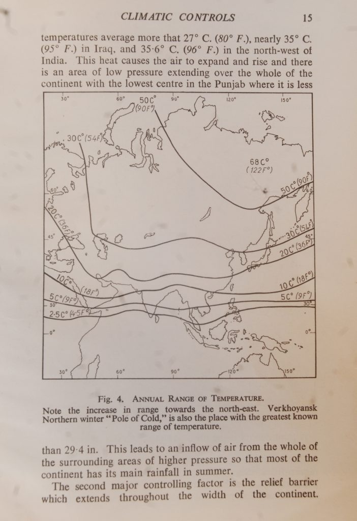
Fig. 4. ANNUAL RANGE OF TEMPERATURE.
Note the increase in range towards the north-east. Verkhoyansk Northern winter “Pole of Cold,” is also the place with the greatest known range of temperature.
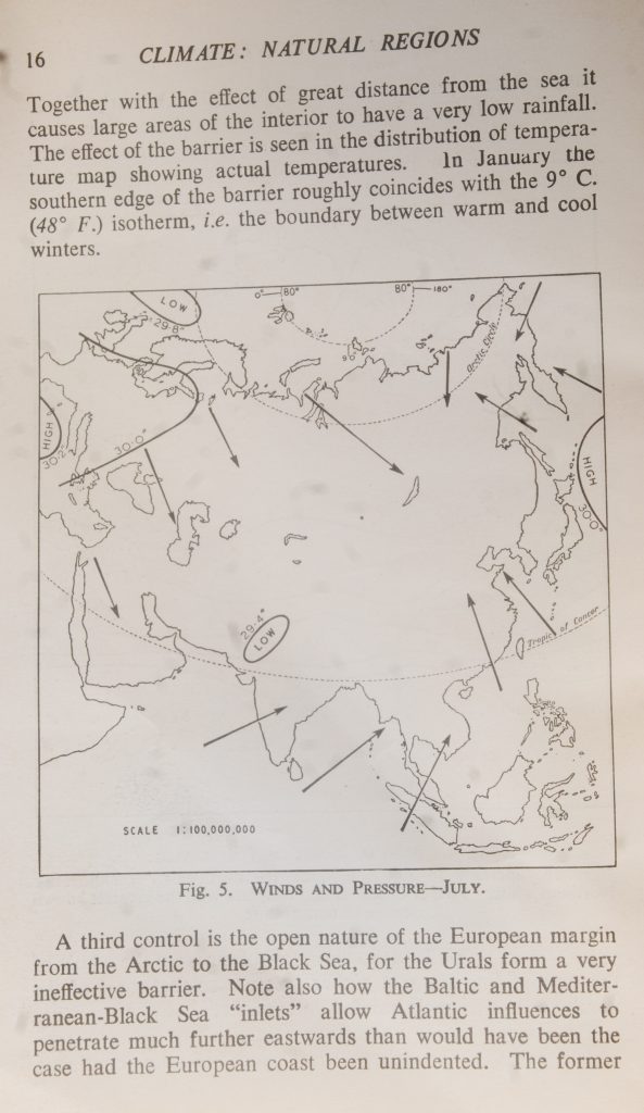
than 29.4 in. This leads to an inflow of air from the whole of the surrounding areas of higher pressure so that most of the continent has its main rainfall in summer.
The second major controlling factor is the relief barrier which extends throughout the width of the continent.
CLIMATE: NATURAL REGIONS
Together with the effect of great distance from the sea it causes large areas of the interior to have a very low rainfall. The effect of the barrier is seen in the distribution of tempera- ture map showing actual temperatures. In January the southern edge of the barrier roughly coincides with the 9° C. (48° F.) isotherm, i.e. the boundary between warm and cool winters.
Tropic of Cancer
Fig. 5. WINDS AND PRESSURE-JULY.
A third control is the open nature of the European margin from the Arctic to the Black Sea, for the Urals form a very ineffective barrier. Note also how the Baltic and Mediter- ranean-Black Sea “inlets” allow Atlantic influences to penetrate much further eastwards than would have been the case had the European coast been unindented. The former
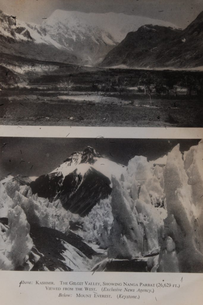
Above: KASHMIR. THE GILGIT VALLEY, SHOWING NANGA PARBAT (26,629 FT.) VIEWED FROM THE WEST. (Exclusive News Agency.)
Below: MOUNT EVEREST. (Keystone.)
THE JORDAN RIFT-VALLEY, SHOWING RIVER MEANDERS. (Exclusive News Agency.) Below: SIBERIAN TUNDRA, WITH HERD OF REINDEER. (Exclusive News Agency.)

has its greatest effect in the summer when the low pressure of Central Asia allows depressions to cross the continent. This accounts for the belt of fairly heavy rainfall shown on the summer rainfall map as extending across the Siberian Plain. In winter the intense high pressure over the land-mass
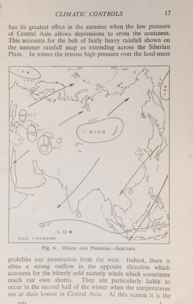
Fig. 6. WINDS AND PRESSURE-JANUARY.
29.8″
C –
prohibits any penetration from the west. Indeed, there is often a strong outflow in the opposite direction which accounts for the bitterly cold easterly winds which sometimes reach our own shores. They are particularly liable to occur in the second half of the winter when the temperatures are at their lowest in Central Asia. At this season it is the
CLIMATE: NATURAL REGIONS
Mediterranean “inlet” which has the greater effect on Asiatic climate for it is then that Atlantic depressions follow more southerly routes. Some of them enter and pass right across the Mediterranean bringing rain to an area extending from Anatolia to Upper Ganges Basin and from Palestine to the Caspian.
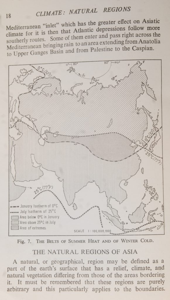
Fig. 7. THE BELTS OF SUMMER HEAT AND OF WINTER COLD.
THE NATURAL REGIONS OF ASIA
A natural, or geographical, region may be defined as a part of the earth’s surface that has a relief, climate, and natural vegetation differing from those of the areas bordering it. It must be remembered that these regions are purely arbitrary and this particularly applies to the boundaries.
Normally on a journey across a continent one would pass very gradually from one region to another.
Bearing these points in mind, let us apply them to Asia. We may divide the continent into 13 major natural regions. The table on pp. 24-7 shows the climatic statistics for places
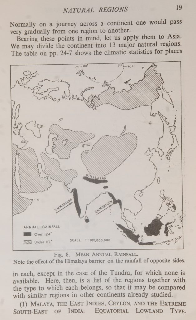
Fig. 8. MEAN ANNUAL RAINFALL.
Note the effect of the Himalaya barrier on the rainfall of opposite sides.
in each, except in the case of the Tundra, for which none is available. Here, then, is a list of the regions together with the type to which each belongs, so that it may be compared with similar regions in other continents already studied.
(1) MALAYA, THE EAST INDIES, CEYLON, AND THE EXTREME SOUTH-EAST OF INDIA. EQUATORIAL LOWLAND TYPE.
CLIMATE: NATURAL REGIONS
Similar regions:
Amazon lowlands, Congo Basin, and Guinea coastlands; north-west coast plain of South America; coastal lowlands of Central East Africa.
(2) A BELT EXTENDING FROM THE WEST COAST OF INDIA THROUGH BURMA, SIAM, AND INDO-CHINA TO THE EXTREME SOUTH OF CHINA. MONSOON TYPE. Similar regions:
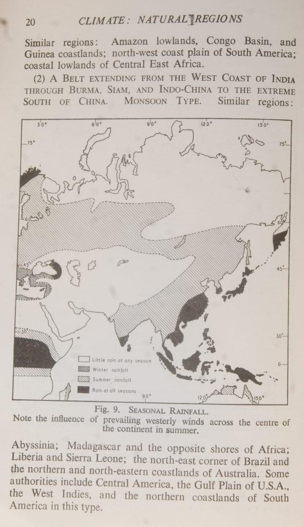
Fig. 9. SEASONAL RAINFALL.
150°
Note the influence of prevailing westerly winds across the centre of the continent in summer.
Abyssinia; Madagascar and the opposite shores of Africa; Liberia and Sierra Leone; the north-east corner of Brazil and the northern and north-eastern coastlands of Australia. Some authorities include Central America, the Gulf Plain of U.S.A., the West Indies, and the northern coastlands of South America in this type.
Normally on a journey across a continent one would pass very gradually from one region to another.
Bearing these points in mind, let us apply them to Asia. We may divide the continent into 13 major natural regions. The table on pp. 24-7 shows the climatic statistics for places
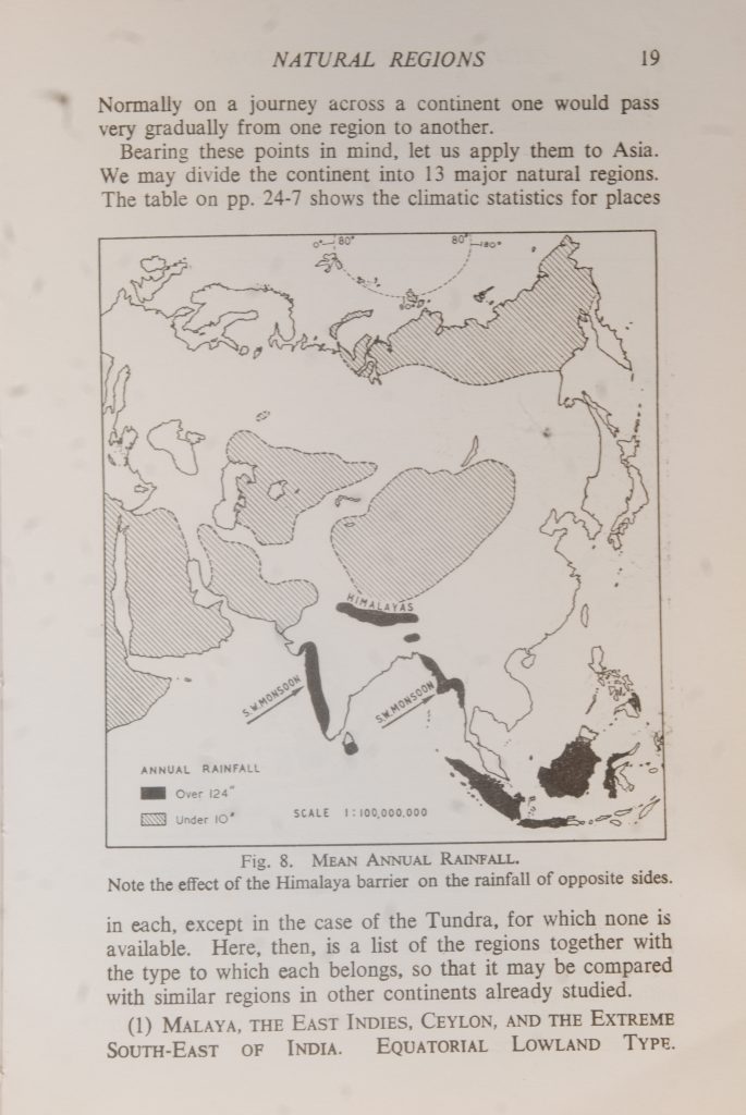
Fig. 8. MEAN ANNUAL RAINFALL.
Note the effect of the Himalaya barrier on the rainfall of opposite sides.
in each, except in the case of the Tundra, for which none is available. Here, then, is a list of the regions together with the type to which each belongs, so that it may be compared with similar regions in other continents already studied.
(1) MALAYA, THE EAST INDIES, CEYLON, AND THE EXTREME SOUTH-EAST OF INDIA. EQUATORIAL LOWLAND Type.
Similar regions: Amazon lowlands, Congo Basin, and Guinea coastlands; north-west coast plain of South America; coastal lowlands of Central East Africa.
(2) A BELT EXTENDING FROM THE WEST COAST OF INDIA THROUGH BURMA, SIAM, AND INDO-CHINA TO THE EXTREME SOUTH OF CHINA. MONSOON TYPE. Similar regions:
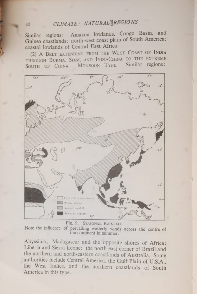
Fig. 9. SEASONAL RAINFALL.
Note the influence of prevailing westerly winds across the centre of the continent in summer.
Abyssinia; Madagascar and the opposite shores of Africa; Liberia and Sierra Leone; the north-east corner of Brazil and the northern and north-eastern coastlands of Australia. Some authorities include Central America, the Gulf Plain of U.S.A., the West Indies, and the northern coastlands of South America in this type.
(3) ARABIAN PENINSULA AND THE LOWER INDUS BASIN. HOT DESERT TYPE. Similar regions: the North African deserts, the Kalahari, the Atacama, the West Australian, and the North American deserts.
(4) THE WESTERN SHORES OF ANATOLIA, SYRIA, PALESTINE, AND THE MESOPOTAMIAN LOWLAND. EAST MEDITERRANEAN TYPE. Similar regions: the Valley of California, the Santiago Valley of Chile, the Kalgoorlie area of West Australia.
(5) IRAN AND CENTRAL ANATOLIA. IRAN TYPE. Similar regions: Plateau of the Shotts (Algeria); the Meseta (Spain); the Basin of the Great Salt Lake (U.S.A.).
(6) TURKISTAN. TURAN TYPE. Similar regions: the high plains east of the Rockies; North-West Argentina; the South African Veldt; the Murray-Darling Basin.
(7) SOUTH-WESTERN SIBERIA, CENTRAL
MANCHURIA.
PRAIRIE OR CONTINENTAL TYPE. Similar regions: the American Prairies, the Plate Lowlands; the Black Earth Region of the Ukraine.
(8) TIBET.
Plateau.
TIBET TYPE. Similar region: the Bolivian
(9) THE GOBI DESERT; THE TARIM BASIN. DESERT TYPE. Similar region: Patagonia.
TEMPERATE
(10) THE SIBERIAN FOREST. NORTHERN FOREST TYPE. Similar regions: the Alaskan and Canadian Forest belt; the Scandinavian and North Russian Forests.
(11) NORTHERN CHINA AND NORTHERN JAPAN, EASTERN SIBERIA. ST. LAWRENCE TYPE. Similar region: the north- east of North America (Newfoundland, the Great Lakes, St. Lawrence Valley, Maritime Provinces, New England).
CHINA (12) SOUTH-EASTERN CHINA, SOUTHERN JAPAN. TYPE. Similar regions: South-Eastern U.S.A., South-Eastern Brazil, coastal plains of New South Wales and Queensland. Similar (13) THE SIBERIAN TUNDRA. TUNDRA TYPE. regions: the continuation into Northern Europe, the Tundra of Arctic Canada, Labrador, and West Greenland.
Let us now examine each of these regions in more detail to study the climatic characteristics and the natural vegetation.
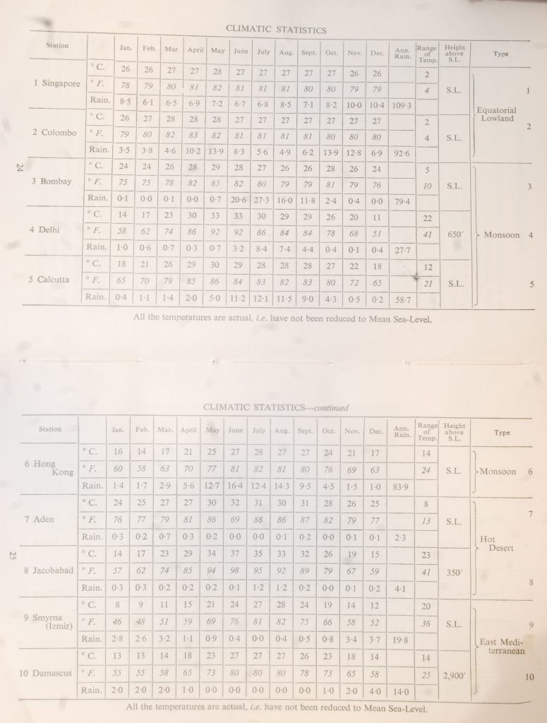
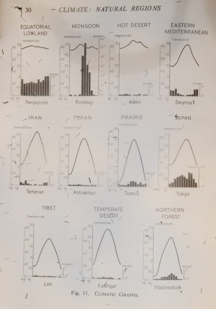
(1) MALAYA, THE EAST INDIES, CEYLON, SOUTH-EAST OF INDIA. Climate.-As the figures for Singapore show, there is very little difference in temperature throughout the year. Note that the average maximum is reached in May just after the period of overhead sun for the latitude. From its near-
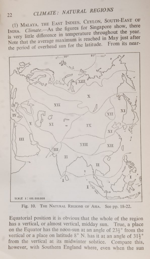
Fig. 10. THE NATURAL REGIONS OF ASIA. See pp. 18-22.
Equatorial position it is obvious that the whole of the region. has a vertical, or almost vertical, midday sun. True, a place on the Equator has the noon-sun at an angle of 231° from the vertical or a place on latitude 8° N. has it at an angle of 311° from the vertical at its midwinter solstice. Compare this, however, with Southern England where, even when the sun
THE EQUATORIAL LOWLANDS
is at its highest, the angle is 271° and in midwinter it is 741° from the vertical.
Although there is a very small annual range of temperature, there is a fairly high diurnal one. Thus Singapore has an average diurnal range of 10 C.° (14 F.°) and this is typical of the region. The atmospheric pressure remains low throughout the year owing to the heat. At Singapore the average is just about 29.8 in., which is also the figure for Jakarta (Batavia). At Colombo there is a slight variation, the pressure rising to nearly 29.9 in. in January and falling to just below 29.8 in. at midsummer.
Because of the constant low pressure the air rises. It is saturated with moisture and, on cooling, releases most of it so that throughout the year there is a heavy rainfall. The mean annual rainfall at Singapore is 92.9 in. In no month does it fall below 6 in., but there is a definite maximum of over 10 in. in December. At Colombo there is an annual rainfall of 87.2 in. with double maxima in May and October of about 13.5 in. In February the rainfall decreases to 2 in. and in August to 3 in. This seasonal fluctuation is a charac- teristic of places in the Equatorial lowlands. In the case of Colombo, which is on latitude 7° 1′ N., it occurs just after the two periods of overhead sun. Jakarta has a rainfall of 70-8 in. with a maximum of 12.5 in. in February and a minimum of 2 in. in August. Note that it is situated on latitude 6° 13′ South and that the maximum occurs not long after the sun has passed overhead on its apparent northward journey whilst the minimum is at the season when the angle of midday sun is nearly at its lowest. At Sandakan in Borneo there is an annual rainfall of 120 in., the wettest month being January (18 in.) and the driest, April (3.5 in.). Throughout the region, in common with other Equatorial lowlands, there is usually a severe thunderstorm in mid- afternoon.
All the places quoted are at sea-level but the area contains many mountain ranges and plateaux. On these, of course, the rainfall is very much heavier and the temperature lower, e.g. on the highlands of Java and Sumatra there are quite extensive areas where the average temperatures remain below 64° throughout the year.

Natural Vegetation.-A hot humid atmosphere is, as all gardeners know, the most favourable for plant growth. Combine this with an extremely fertile soil and you have the “optimum” conditions. There are many types of soil in these Equatorial areas-alluvial or volcanic in the main- and they all contain a considerable amount of humus. This is inevitable in a forested region because of the steady accumulation of decayed vegetable matter-fallen leaves, dead trees, etc. Heat, moisture, bacteria, and insects contribute to extreme rapidity of decay. As a result there is not only a luxuriance of vegetation unparalleled in any other type of region in the world (except in certain monsoon forests where the rainfall is heavy) but also a tremendous variety of types of plant life. This variety is an economic disadvantage because valuable timber rarely appears in “stands” but is scattered about amongst masses of valueless material. There are usually three “layers” of trees. First, there are the giants of over 100 ft., then come those of medium height (60 ft.-80 ft.), and finally the shorter ones of about 30 ft. They are bound together by cable-like creepers (lianas) and the intervening spaces are filled with masses of undergrowth. Germination and growth are so rapid that a track cleared with great difficulty will disappear in a very short time unless constant work is put into maintaining it. Owing to the lack of seasonal climatic variations, there is no special seed or harvest time. Trees bear flowers, unripened and ripened seeds, at the same time and all the time.
These conditions apply to the coastal lowlands, but as the mountains are climbed the forest remains thick owing to the heavy rainfall. This mountain rain forest has not such a variety of types because as the temperature decreases with altitude nature becomes more selective.
(2) THE MONSOON LANDS. Climate.-Over the vast area which we have included under this heading there is, of course, a great variety of local conditions. There are, however, certain major characteristics which are common to the whole of the area. The word “Monsun” means “seasonal wind” and monsoon regions are those which have exactly opposite winds in summer to those which blow in winter. They occur where land-masses in temperate latitudes border tropical seas,
MONSOON LANDS
e.g. over Asia the pressure is very high in winter, whereas over the warmer tropical sea the relatively high temperatures cause low pressure. So the air flows from land to sea and the monsoon lands experience drought. In summer, on the other hand, the very high temperatures over North-West Pakistan cause the development of a powerful low pressure system, but over the Indian Ocean the relatively cool temperatures give rise to high pressure. As a result air flows strongly from sea to land and the monsoon lands have their rainfall. It is important to understand that the change does not come suddenly. At the equinoxes there are two short seasons with very unsettled conditions, especially in coastal areas where land and sea influences are most in conflict. It is then,
especially at the autumn equinox, that the very violent cyclonic storms, typhoons, sweep across the Bay of Bengal and the South China Sea.
The variety of conditions which we have mentioned is connected with the amount of rainfall and the winter tempera- tures. In India, for example, the mean annual rainfall of the monsoon area varies from about 10 in. in the north-west to 430 in. on the southern slopes of the Khasi Hills of Assam. As to winter temperatures, they range from 10° C. (30° F.) in the Punjab to over 25° C. (77°
F.) in southern Burma.
For our specimen climatic station we have selected Bombay. Note especially the sudden jump in rainfall from 0.7 in. in May to 20-6 in. in June. Other places with similar conditions are: Rangoon with 99.6 in. of rain, 21.5 in. in July; Calcutta with 58.7 in., July 12.1 in.; Hong Kong, 83-4 in., 16-4 in. in June. In the lower rainfall group we have Delhi, annual rainfall 27.7 in., 8.4 in. in July; Lahore, 20.5 in., 6.7 in. in July; Mandalay, 35.1 in., 5.7 in. in May; Hyderabad (Deccan), 35.6 in., 7 in. in September. At the other extreme there is Cherrapunji (Assam) with 432 in., 99-6 in. in July, the wettest place in the world, and Mangalore (South-West India), 125-7 in., 37 in. in July.
Natural Vegetation.-As the monsoon lands are so densely populated a natural vegetation map does not convey a very accurate idea of the existing conditions. It only attempts to show what the vegetation would be if man had not felled much of the forest and ploughed up the grassland. With
THE OLD WORLD DESERT
such great variations of soil, altitude, and above all, of rain- fall, it is not possible to speak of a monsoon vegetation except in so far as to say that the greater part of the area is naturally covered with forest of one kind or another. Thus the lower Ganges Basin and the coastlands of Burma and Indo-China have a dense jungle very similar to that of the Equatorial lowlands, with much mangrove swamp along the shores. Very little of the original forest is left in the first-named area for most of it has been cleared for rice-fields. In Bengal trees are even being planted as future fuel supplies to replace cow- dung now so much needed as manure after many years of cul- tivation. The North-Eastern Deccan and most of the Ganges Basin together with the interiors of Burma and Indo-China have a much more open type of forest, a very characteristic tree of the lowlands being teak. On the uplands of the Deccan the banyan is quite common. It is able to withstand the winter drought by reason of its branches taking root in search of moisture. It is like the bao-bab of the Sudan, a similar summer rainfall region. In North-Western India, the Central and Southern Deccan, the rain-shadow valleys of Burma and Indo-China, there is scrubland or semi-desert vegetation with drought-resisting acacias and tamarisks. On the high mountain ranges, of course, there are belts of vegetation in accordance with altitude, ranging from dense rain forest on the lower slopes, through forests of gaily flowering rhododen- drons, camelias, and magnolias followed by pine forests and then by meadows of Alpine mosses and lichens culminating in ice-desert.
(3) THE OLD WORLD DESERT. Climate.-The area of the Lower Indus Basin, most of which is composed of the Thar Desert, has in summer a very low average atmospheric pressure. Indeed, in July it is as low as 29-4 in. which is the lowest average pressure for any part of the world at any time of the year. Low pressure means rising air, so that from all the surrounding regions of land and sea alike, other surface air moves in from high pressure belts to take its place. In its turn this new supply of air becomes heated and rises, and so the process goes on. Owing to the rotation of the earth, this inward moving air does not flow straight towards the low pressure centre, but makes its way gradually in ever-narrowing
CLIMATE: NATURAL REGIONS
circles in an anti-clockwise direction. This is an illustration of Ferrel’s Law which states that all moving fluids are deflected towards the right in the northern hemisphere and to the left in the southern. The explanation for this may be put simply as follows: the earth makes one revolution around its own axis in twenty-four hours, but, as the earth is spherical, a point nearer the Equator has to travel through space at a much faster rate than those in higher latitudes where the circumfer- ences of the parallels of latitude are less. To take definite examples the circumference of the earth at the Equator is 24,500 miles, whereas at the Tropic it is about 18,000 miles. At the former, a point travels through space at just over 1,000 miles an hour, but at the latter a point travels at about 750 miles an hour. Now when a particle of air or water begins to move northwards in the northern hemisphere it passes from more rapidly moving to more slowly moving latitudes, but it tends itself to retain the speed of its original latitudes. Therefore, instead of moving along a meridian of longitude, it turns gradually to the right. It will be seen that if this process continues, the particle will tend to describe a circle, for in the second half of its journey it will begin to turn back towards the Equator and so travel towards latitudes moving more rapidly.
Its deflection will still be towards the right. In the case of the Thar low pressure centre, our particle of air is affected by two influences-the rotation of the earth and the centre of low pressure. The latter tries to pull it in, but the former deflects it to the right all the time, so that it moves in an anti-clockwise circle. By the time that the flow of air reaches the low pressure centre it has passed over much land and has therefore lost its moisture. This accounts for the summer drought of the Thar. As Arabia is to the west of the low pressure, its winds are northerly, so that they have blown across much of the land-mass and are also dry. In the winter there is high pressure over much of the Asiatic land-mass so that the air flows from land to sea and the desert area shares in the general drought.
An examination of the figures for Aden reveals that most of the very small amount of rain falls in the late winter when the temperatures are lowest and the pressure highest. This is caused by local storms, as may be seen from the fact that on the neighbouring Jebel of Yemen there is a summer rainfall of
THE OLD WORLD DESERT
just over 10 in. At Jacobabad in the north-west corner of the Thar Desert there is an annual rainfall of 3.8 in., mainly occurring in July and August. This very light rainfall is a characteristic of the deserts, very few areas being completely without rain. When rain does fall it usually comes as a torrential downpour, being caused by local thundery condi- tions. Indeed, this occasional rain often does more harm than good, causing the wadis to be filled with violently rushing water and sweeping away the meagre barley crops. Frequently places are affected by such a storm only once in a few years so that an average rainfall of 3 in. may be arrived at by including one storm yielding, say, 10 in., the remainder of the period being absolutely dry.
One is apt to think of these deserts as permanently hot, and this impression tends to be confirmed if one consults a climatic chart. This, however, usually confines itself to giving only the mean average temperatures and thereby conceals a most important characteristic of the climate the great diurnal range of temperature. For example, at Jacobabad it averages about 27 C.° (80 F.°) for most of the year. Voyagers along the Red Sea experience a practical illustration of this at sun- set, for the temperature suddenly falls appreciably and the unwise expose themselves to the risk of chills if they do not immediately put on warmer clothing. The climatic feature is caused mainly by the fact that deserts consist of polished sand particles and hard rock face so that during the daytime the sun’s rays are radiated immediately, causing very high air temperatures. The mean maximum temperature, e.g. at Jacobabad in August, is 45° C. (113° F.). At sunset, however, as there is no stored heat, the thermometer falls quickly. A contributory factor is the absence of cloud which results in the heat-rays being dispersed throughout the atmosphere instead of being retained in the lower layers. Thirdly, there is the absence of vegetation.
Another characteristic of the desert is the sand storm. This is caused by sudden local changes of pressure setting up vigorous air displacement. Once set in motion the air gathers speed, for in the deserts there are few relief barriers to check its progress.
CLIMATE: NATURAL REGIONS
Natural Vegetation.-As in most other parts of the world the Arabian and Thar Deserts have only small proportions of their areas absolutely devoid of vegetation. In Arabia the true desert extends along a narrow belt through the centre of the peninsula widening out in the south to form the Rub’al Khali or Great Stony Desert. Surrounding this there is semi-desert country, mainly with tufts of coarse grass amidst the sand and with quite frequent oases, especially in the south-west. The latter usually support date palms. In the Syrian Desert to the north-west there is a strange type of sporadic vegetation. After a storm, which may come to a locality only once in ten years, the ground is literally carpeted with dwarf plants-the manna of the Bible. These germinate, blossom, seed, and die all in a few days, for the porous soil soon dries out, and this hurried life-cycle is their only way of preserving their species.
(4) THE MEDITERRANEAN SHORELANDS AND THE MESOPO- TAMIAN TROUGH. Climate. This region may be said to experience an East Mediterranean climate for, although it has the typical winter rainfall, there are several features which distinguish it from the true Mediterranean. Thus, the range of temperature is greater because the land-mass influence is stronger than the sea influence. For example, whereas coastal places in the West Mediterranean have an average annual range of temperature of 14 C.° (25 F.°), that at Smyrna is 20 C.° (36 F.°). Inland, of course, the range increases, e.g. at Baghdad it is 25 C.° (45 F.°). Not only is the rainfall less, but also the summer drought is more complete. In the East Mediterranean area, average pressure is highest in winter as is the case further west. The rainfall is caused by the irregular passage of low pressure systems which enter the Mediterranean through the Gate of Carcassonne and the Gibraltar Strait. Sometimes these depressions penetrate to the Mesopotamian Trough and even along the Persian Gulf. It is the light rainfall from these which entitles us to include Mesopotamia in this region. The annual rainfall at Baghdad is 6.6 in. and it occurs from November to April.
Natural Vegetation. Forming a narrow fringe round the shorelands of the Black Sea and Eastern Mediterranean there is a continuation of the belt of typical evergreen shrubs and
IRAN AND TURAN TYPES
trees. Some of the hills, notably the Lebanon Mountains of Syria, had a natural forest cover until man removed such trees as the famous cedars for building purposes or allowed goats to kill others, as happened in Cyprus. Much re-afforestation work has been carried out, e.g. the Balfour Forest of Israel. All sorts of drought-resisting devices have been developed. Plants are long-rooted to reach the moisture in the sub-soil; they have developed long, narrow leaves with thick wax-covered skins. These leaves are fleshy and contain cells for moisture storage for use during the summer drought. This accounts for the evergreen nature of Mediterranean vegetation. Many of the plants are rich in oil and give off powerful aromas when touched or when the leaves are crushed. The myrtle is a good example of this. Seeds are often protected by oily or juicy fruits. Indeed, the most characteristic plant, the olive, is well represented, e.g. on the Mount of Olives, Israel.
(5) IRAN, ANATOLIA, AND AFGHANISTAN. Climate.-Here again the “Mediterranean” influence is evident, for there is a definite winter rainfall maximum, e.g. at Teheran in Iran, of a total rainfall of 9 in., 7.9 in. falls in the six months November- April. At Kabul in Afghanistan the annual rainfall is 13 in. and of this over 11 in. falls from November to April. In this region, however, the range of temperature is greater. At Teheran it is 28 C.° (52 F.°) [1° C. (33° F.) January, 29° C. (85° F.) July]; at Kabul it is 25 C.° (46 F.°) [-1° C. (30° F.) January, 24° C. (76° F.) July]. Another characteristic is the great diurnal range in the summer months-17 C.° (30 F.°) at Teheran and 18 C.° (32 F.°) at Kabul.
Natural Vegetation.-The characteristic vegetation of this region is the coarse grass of the High Steppe and the salt bush of inland drainage areas, known in Iran as the Dasht, with patches of true desert.
(6) TURKISTAN. Climate.-In Central Asia, in the lowland extending from the Caspian to the foothills of the Pamir Plateau, there is an area exposed to the north and screened from the south. The figures for Astrakhan, just outside Asia on the Caspian shore, give a very fair idea of the climatic conditions. Note especially the severity of the winters compared with the heat of the summers. The precipitation is light but the summer rainfall (April-September) is in the ratio of 1-73 to 1 to the winter snowfall. In winter, bitterly cold north-east winds bring fine snow.
Natural Vegetation.-Although there are patches of true desert, notably in the Kizil Kum and Kara Kum to the south of the Aral Sea, the greater part of the region is covered with poor steppe. In the area below sea-level to the south and south-east of the Caspian, there is much salt bush, which absorbs salt in solution through its roots and exudes it on its leaves which glisten in the sunshine.
(7) THE ASIATIC STEPPES. There are two regions which may be included under this heading: —
1. The famous Kirghiz Steppe which extends in a belt from west to east with its axis along latitude 50% N. and which is continued to the north-east, in the Upper Ob and Yenisei Basins, by an area of mixed forest and grassland. The Canadians call a similar tract to the north and east of their prairies, the Grove Belt.
2. The West Manchurian lowland.
Climate. The first of these regions is far removed from the sea influences and so experiences great extremes of pressure between midsummer and midwinter, e.g. at Barnaul this varies between 30-45 in. in January and 29-75 in. in July. This variation is mainly caused by the corresponding temperature changes because the annual range of temperature is about 38 C.° (70 F.°) i.e. from about – 18° C. (0° F.) in midwinter to about 20° C. (68° F.) in midsummer. The rainfall is pre- dominantly a summer one, e.g. Barnaul has 70 per cent. of its 14 in. in the period May-October; Tomsk 66 per cent. of its 19.8 in., and Semipalatinsk 63 per cent. of its 7.3 in. in the same period. This summer rainfall is caused by the penetra- tion of westerlies from the Atlantic. In the winter the chief precipitation is snowfall occurring in the autumn half. In this region temperatures often fall far below the average in mid and late winter, when north winds bring blizzards of fine powdery snow.
In Manchuria the extremes of temperature are equally great, e.g. at Shenyang they range from -13° C. (8° F.) in January
TIBET
to 25° C. (77° F.) in July, and at Harbin from -19° C. (-2° F.) in January to 22° C. (72° F.) in July. The rain- fall is, of course, heavier than that of Central Asia and the summer proportion is even higher, i.e. 78 per cent. of about 24 in. That is because south-east winds are drawn into the land-mass owing to the low pressure over the interior. The moderate rainfall is caused by the enclosed nature of the lowlands, because they are in the rain-shadow of the Korean Highlands. The winter drought is caused by the reversal of pressure and winds so that they are now off shore.
Natural Vegetation. The low winter temperatures, the heat of summer, the moderate rainfall, and the light soils combine to prevent tree growth so that the temperate grassland predominates. Along the southern edge of the Kirghiz the grass merges gradually into semi-desert. In the north-east trees gradually make their appearance, forming a transition between the Steppe and the northern forests. In the west of Manchuria, where the land rises towards the Khingan Range, there is also a belt of semi-desert caused by the porous nature of the loess soil.
The temperate grasslands are at their best in spring when the melting of the snow and the coming of the early rains combine to moisten the soil. Fresh green blades of grass are mingled with myriads of flowers. In the heat of summer the green gives way to brown as the grass becomes parched.
(8) TIBET. The great plateau of Tibet, bounded to the north by the Altyn Tagh and to the south by the Himalayas, opens to the east into series of parallel ranges and deep valleys. The plateau averages 14,000 ft. above sea-level and none of the valleys falls much below 12,000 ft.
Climate. On the exposed plateau the winters are bitterly cold and icy snow-laden winds make the plateau impossible to cross. Even in summer, conditions are not much better. In the valleys, however, there is greater shelter and, as the figures for Leh show, the summers are pleasantly warm. Note the low rainfall. On the high fold ranges the snow comes chiefly in summer, the winters being cold and dry. This summer snowfall is, of course, caused by the inflowing monsoon winds rising up the mountain slopes.
Natural Vegetation.-Over the greater part of the plateau, the vegetation is akin to that of the tundra with much moss and lichen, although in the north-east round the high lake, Koko Nor, there is an extensive tract of marshland. On the surrounding mountains and along the high ranges which cross the plateau tundra gives way to ice-desert.
(9) THE GOBI DESERT AND THE TARIM DEPRESSION. Climate.-Lower in altitude but higher in latitude than the Tibetan Plateau, this region is equally cold in winter but has a deficiency of rainfall. In the extreme west of the Tarim Basin, Kashgar has a January temperature of -6° C. (22° F.) and a July one of 27° C. (81° F.), whilst in the north-east Ulan-Bator (Urga) varies from -26° C. (-15° F.) to 17° C. (63° F.). Kashgar’s rainfall is 3-5 in., almost all of it in
summer.
Natural Vegetation. Much of Mongolia consists of the Gobi or Shamo Desert and there is also true desert in the centre of the Tarim Depression. In Northern Mongolia there is enough rain to support coarse grass. It was from this region that the Mongol horsemen swept into Europe and China, and it is still inhabited by nomadic horse and cattle men. Around the edge of the Tarim Basin there are frequent oases of good grass watered by streams from the surrounding mountains where there is a higher rainfall and where there are, in some cases, glaciers.
(10) THE SIBERIAN FORESTS extending from the Urals to the Pacific Coast. Climate. Throughout this area the winters are extremely cold. Indeed, Verkhoyansk, in the north-east on the edge of the forest, is known as the winter North Pole of Cold because it is the coldest place in the northern hemisphere with a mean January temperature of -51° C. (-59° F.). With a summer temperature of 16° C. (60° F.) it has the greatest known range of temperature 66 C.° (119 F.°). Although other places are not so cold as Verk- hoyansk, they are cold enough. Irkutsk, in the extreme south, has a January temperature of -21° C. (-5° F.) and a July one of 18° C. (65° F.). Vladivostok, on the south-east coast, has a January temperature of -15° C. (5° F.) and an August one of 21° C. (69° F.). Okhotsk, on the north-east coast, has
THE NORTHERN FORESTS
a January temperature of -23° C. (-10° F.) and a July one of 13° C. (55° F.). Rainfall is moderate throughout the area and occurs mainly in summer, e.g. at Verkhoyansk it is only 5 in., of which 3 in. fall in June, July, and August. At Vladi- vostok it is 22.5 in., of which 17.5 in. fall in the period from May to October. At Irkutsk it is 15 in., with 10.5 in. between May and October. The winter precipitation is, of course, mainly in the form of snow which averages about 3 ft. at Irkutsk and a great deal more in the north-western regions. A feature of the climate is the great diurnal range of tempera- tures, especially in the spring, e.g. at Verkhoyansk in April the range is 20 C.° (86 F.°) This is because the sun’s rays begin to make themselves felt in the day-time but the still frozen earth quickly cools the air at night.
Natural Vegetation.-Only very hardy vegetation can stand up to these conditions. Most of this vast area is covered with a forest of small coniferous trees, but the actual composition of the forest varies from west to east. From the Urals to the Yenisei the fir, spruce, larch, and pine trees are interspersed with a great deal of marshland, in which there are large areas of dead trees. From the Yenisei to the Pacific the forest is more continuous. The difference is mainly due to the geology, for the boulder clay of the western half is more favourable to the development of marshland than the hard rock of the eastern. In the extreme east where the rainfall is heavier and the winters are mild the vegetation is more mixed, for amongst the conifers there are patches of such deciduous trees as the oak and the elm, the maple and the walnut. The conifers adapt themselves to the winter cold in several ways. They have long roots below the frozen top soil, their bark is thick to protect the sap which circulates throughout the year. They are evergreen, their leaves being needle-shaped thus exposing the minimum surface area. The branches of many types slope downwards, which has the advantage of preventing the weight of the frozen snow from snapping them, as happened to many of our own trees in the severe winter of 1962-3.
(11) NORTHERN CHINA AND NORTHERN JAPAN, EASTERN SIBERIA. Climate.-This region is very much affected by the alternations of temperature and pressure over the interior.
Indeed, some authorities include much of it in a Temperate Monsoon Climate, but it seems preferable to think of mon- As this area has soons as confined to tropical areas. characteristics comparable to those in North-Eastern America we include it in the St. Lawrence type.
The winters are cold because the Asiatic high pressure causes an outflow of bitterly cold air. Mainland areas and those on the west coast of Japan experience much colder conditions than those on the east coast, as a comparison of the figures for Vladivostok (a border line case) and Tokyo will show. This is partly because of the shelter afforded to the latter by the mountain backbone of Honshu, and partly because the Japanese coast is affected by the warm Kuro Siwo current which washes the eastern shores contrasting with the cold northerly current which flows along the main- land coast. The summers are hot throughout the region. There is a definite summer maximum rainfall. Here again Japanese stations show distinct differences from those on the mainland. The total amount received is greater, and it is more evenly distributed throughout the year.
Natural Vegetation. Most of the area has been cleared of its natural vegetation, but where it remains it is a close forest of deciduous trees such as the wild cherry of Japan and the mulberry of North-East China and Japan, together with bamboo on the lowlands and conifers on the high ground.
(12) SOUTH-EASTERN CHINA, SOUTHERN JAPAN. Climate. -This area experiences much higher summer temperatures than Region 11, and the winters though still cool are notice- ably warmer. Compare Vladivostok [January -15° C. (5° F.), August 20° C. (68° F.)] with Shanghai [January 3° C. (38° F.), July-August 27° C. (81° F.)]. This is, of course, the natural effect of the lower latitude of the latter, but we can still note the influence of the outflow of cold air from the interior in winter. The rainfall is fairly heavy with a pro- nounced summer maximum. In winter the prevailing wind is north-easterly so that a certain amount of moisture laden air is blown inland, but in summer the wind is directly on- shore from the south-east.
An interesting comparison may be made between the rain- falls of Shanghai and Wuhan. The former, although on the
THE TUNDRA
coast, has only 44 in., and the latter, well up the Yangtse Valley, has 51 in. The former ranges from 2-2 in. in January to 6.5 in. in June, and the latter from 1.5 in. in January to 9.2 in. in June. The differences may be explained by the fact that in winter Shanghai is more affected by the north- east winds, whereas in summer Wuhan, which is in an enclosed valley, is much affected by convectional rainstorms.
Natural Vegetation.-Here again little is left in most parts, but where it is, there is dense sub-tropical forest, particularly on the more sparsely-populated Formosa and such nearby islands as Nan Ko which have a very high rainfall. The bamboo is very common in this area.
(13) THE TUNDRA. A narrow belt along the Arctic shore. Climate. The northern limit of tree-growth is taken to be the 10° C. (50° F.) July isotherm so that all the region to the north of this may be included in the tundra. The summers are on the average cool, i.e. under 10° C. (50° F.), but as the region is beyond the Arctic Circle the sun does not set through- out the period March-September so that in sheltered valleys quite high temperatures are recorded at “midday,” i.e. when the sun is at its highest. The winters are, of course, bitterly cold, varying from -40° C. (-40° F.) in January in the east to -22° C. (-8° F.) in the west. The difference may be accounted for by the influence of the warm North Atlantic Drift and south-west winds. There is much snow in the winter and in summer there is a small amount of rain, usually a drizzle.
Natural Vegetation.-The tundra may be sub-divided into three types according to altitude. First there is the high tundra, consisting of barren rock with only moss and lichen. Next there is the middle tundra, i.e. the slope between the hummocky high ground and the river valleys. In some parts this is covered with Arctic grass, a tough kind which with- stands the severe winters. There are also stunted little trees not more than a few inches high but with all the features of their larger counterparts. Berry-bearing bushes like the bilberry and the cranberry are common. The low tundra or valleys are frozen wastes in winter, but in summer the top four feet or so of soil thaws leaving underneath to a depth
CLIMATE: NATURAL REGIONS
of about eight feet a belt permanently frozen. Consequently the flat lowlands become marshy. As the rivers thaw in their upper courses first, the water flows down and adds to the flooding. The marshlands are gay in summer with such bulbs as the snowdrop and crocus. One unpleasant feature in summer is the myriads of mosquitoes which rise from the marshlands. Travellers who have visited both the Equatorial lowlands and the Arctic tundra have declared that they found the insects much the more troublesome in the latter.